
Yes, you can get around Los Angeles without a car, as long as you plan your days by neighborhood and book lodging near a rail stop or a frequent bus line. Metro rail covers the major visitor corridors, buses fill the gaps, and walking, biking, or a short rideshare handle the last mile. A TAP card or a contactless phone tap keeps fares low through fare-capping. Guided tours cover the rest.
TL;DR:
- Choose lodging no more than ten minutes on foot from a rail station or a bus running every 10 to 15 minutes.
- Metro caps fares at about $5 daily and $18 weekly with TAP or contactless payment; cash bus fares do not count toward either limit.
- Use rail for longer trips, but allow for rush hour bus delays and check service alerts before leaving because closures can change station hours.
- Griffith Observatory has no rail service, so plan a bus or rideshare for the hilltop and visit late afternoon to avoid heavier midday traffic.
- Choose a guided bus tour to combine the Hollywood Sign, celebrity homes, and the coast in one day; rent a car for destinations beyond Metro.
Table of Contents
- Where to Stay to Make Car-Free Days Easy
- How Metro Rail and Buses Cover LA’s Visitor Corridors
- What It Costs to Ride and How Fare-Capping Works
- Getting To and From LAX Without Driving
- Sample Car-Free Days by Neighborhood
- What to Check Before Booking Your Hotel or Rental
- Filling the Gaps: Bikes, Scooters, and Rideshare
- Before You Leave: A Trip-Planning Checklist
- When a Guided Tour Beats Public Transit
- Connecting Your Transit Day With a Tour Pick-Up
- Accessibility on Transit and Tours
- Carrying Cameras, Shopping Bags, and Gear on Transit
- How Weather Affects Your Walking and Waiting Times
- A Realistic Take on Car-Free Life in LA
- Skip the Transfers: Book a Guided Tour Instead
- FAQ
- Sources
Where to Stay to Make Car-Free Days Easy
The neighborhood you choose matters more than any app you download. Los Angeles is a collection of walkable pockets connected by rail and bus lines, not one dense downtown, so your lodging should sit inside one of those pockets, close to a station.
- Downtown LA: the strongest rail hub, with access to museums, sports venues, and east-west connections across the county.
- Hollywood / East Hollywood: served by the B Line, with walkable clusters around the Walk of Fame and nearby restaurants.
- Santa Monica / Westside: the E Line runs straight to the coast, and most beach attractions sit within walking distance of the stops.
- Culver City / Mid-Wilshire: the K Line connects to the museum corridor along Wilshire Boulevard.
- West Hollywood / Beverly Grove: dense streets and frequent bus corridors, even without a rail stop of its own.
A simple rule covers most of these choices: book a place within a ten-minute walk of a rail station or a bus line that runs every 10 to 15 minutes. That single decision shapes how much of your trip depends on rideshare.
How Metro Rail and Buses Cover LA’s Visitor Corridors
Metro’s rail network is the backbone of a car-free Los Angeles trip. According to the Metro schedules and rail map, the system includes the A, B, C, D, E, and K lines, plus busway connections that link major visitor corridors across the county.
- A Line: runs from Long Beach through Downtown LA, useful for connecting the harbor area to the city core.
- B Line: the subway through Hollywood, linking Union Station to North Hollywood with stops near the Walk of Fame.
- D Line: serves Koreatown and the Mid-Wilshire corridor, with an extension toward the Westside underway.
- E Line: the light rail to Santa Monica, ending a few blocks from the beach.
- C Line: connects to LAX-area stations and the South Bay.
- K Line: runs through Crenshaw and Inglewood, linking to the museum corridor near Culver City.
Rail works best for longer, cross-neighborhood legs because it runs on a dedicated track and avoids street traffic. Buses fill the gaps rail can’t reach, but they share the road with cars, so build in buffer time during rush hour. For planning, the Metro schedules and rail map lists current routes and service alerts worth checking before you leave, since construction or closures can shift a station’s hours without much notice. Pair that with the Transit app or Google Maps for real-time arrivals.
Rail trips tend to run on a fixed schedule with dedicated tracks, which makes them more predictable than buses stuck in traffic, according to Metro’s route and service listings.
What It Costs to Ride and How Fare-Capping Works
Fares are simple once you understand the capping system. According to Metro’s fare page, riders who pay with a TAP card or a contactless payment never pay more than the daily or weekly cap once they hit it, no matter how many rides they take.
- Buy or load a TAP card at a station vending machine, or use the TAP app on your phone.
- A contactless credit or debit card, or a mobile wallet, qualifies for the same fare-capping benefit.
- Cash works on buses, but you need exact fare, and cash payments don’t count toward the cap.
- Transfers between rides are free within a two-hour window when you tap with the same card.
Metro’s daily cap sits near $5 and the weekly cap near $18, according to Metro’s fare page, which means a few days of steady riding costs less than a single day of parking downtown. Use the same card or phone for every ride during your trip. Switching between a physical TAP card and your phone’s wallet resets the tracking and can cost you the cap.
Getting To and From LAX Without Driving
LAX sits apart from the rail network, but reaching it by transit is straightforward if you time it right. Visit California’s overview of LA Metro notes that improvements at the LAX Transit Center, including the new people mover, have made airport-to-city connections considerably easier for car-free travelers.
- The FlyAway bus runs from LAX to Union Station and a few other regional hubs, a reliable option if your hotel sits near a Downtown rail stop.
- The LAX Transit Center connects to the C and K lines, with onward transfers toward Downtown, Hollywood, or the Westside.
- Metrolink and Amtrak trains from Union Station serve riders heading to other parts of Southern California.
- Build in extra time for luggage. Moving bags between a bus and a train platform takes longer than it looks on a map.
Sample Car-Free Days by Neighborhood
Clustering your sightseeing by neighborhood is the single biggest time-saver in Los Angeles. Here are four sample days built around Metro’s backbone.
- Downtown cultural loop: Start at Union Station, walk to Olvera Street, then take a short rail hop to the Arts District or the Music Center. Budget about four hours including walking segments.
- Hollywood and Griffith Observatory: Ride the B Line into Hollywood, walk the Walk of Fame, then catch a short bus or rideshare leg up to the Observatory since no rail line reaches the hilltop directly. Plan for five to six hours round trip.
- Santa Monica beach day: Take the E Line straight to Downtown Santa Monica, then switch to a bike share dock or walk the last stretch to the pier. A full beach day runs six to eight hours.
- Miracle Mile museum corridor: Use the K Line or a bus along Wilshire Boulevard to hit the La Brea Tar Pits and nearby museums, all within walking distance of each other. Three to four hours covers the main stops.
Pro Tip: Book your Griffith Observatory visit for late afternoon so the bus or rideshare leg up the hill avoids the worst midday traffic.
What to Check Before Booking Your Hotel or Rental
A good car-free base checks a few specific boxes beyond just proximity to a station.
- Confirm the walk to the nearest rail stop or frequent bus line takes ten minutes or less, ideally along a lit, populated street.
- Look for a grocery store or pharmacy within walking distance so you’re not hauling supplies across the city.
- Check how often buses or trains run in the evening, since some lines slow to every 20 or 30 minutes after dark.
- A room that costs a bit more but sits inside a walkable, transit-rich block usually saves you more in time and rideshare fares than it costs upfront.
Filling the Gaps: Bikes, Scooters, and Rideshare
Short hops between a station and your final destination rarely need a car, but they do need a plan.
- Metro Bike Share stations sit near most rail stops, and single rides or day passes work well for beach paths or flat museum corridors.
- E-scooters are common on the Westside and in Hollywood. Park them out of the pedestrian path and off curb ramps when you’re done.
- Rideshare makes sense for the last mile to a hillside destination like Griffith Observatory, or late at night when bus frequency drops. Splitting the fare with a travel companion keeps the cost reasonable.
- Short-term car rental rarely pays off for a visit under a week unless you’re planning a day trip well outside the Metro network, like Joshua Tree, wine country, or even a visit to Deukmejian Wilderness Park in Glendale.
Before You Leave: A Trip-Planning Checklist
A little prep turns a car-free day from stressful into routine.
- Plan each day around one neighborhood cluster and allow extra transfer time, since buses run slower than rail during congestion.
- Check Metro’s service alerts for your planned route the morning you leave, since construction or single-tracking can add delays.
- Carry a backup payment method in case your primary TAP card or phone runs out of charge.
- Pack a portable charger and a small day bag. Keep valuables zipped and stay aware of your surroundings at quiet stations late at night.
Pro Tip: Screenshot your route before you leave in case you lose signal underground on the subway.
When a Guided Tour Beats Public Transit
For visitors trying to see dispersed highlights like the Hollywood Sign, celebrity homes, and the coast in a single day, a small-group guided bus tour cuts out the transfers entirely. Instead of piecing together rail, bus, and rideshare legs, you board once and the driver and guide handle the route.
- Our Hollywood Sign Tour takes visitors to prime viewing spots without a single transfer.
- The Hollywood to Santa Monica Tour links two neighborhoods that otherwise require a rail transfer and a longer walk.
- The Celebrity Homes Tour reaches residential streets that buses rarely serve directly.
Each tour includes onboard video content, audio guides in multiple languages, and small-group sizes that keep the experience personal rather than packed onto a standard charter bus. If you’d rather compare the tradeoffs directly, our guided tour versus rental car breakdown walks through when each option makes more sense.
Connecting Your Transit Day With a Tour Pick-Up
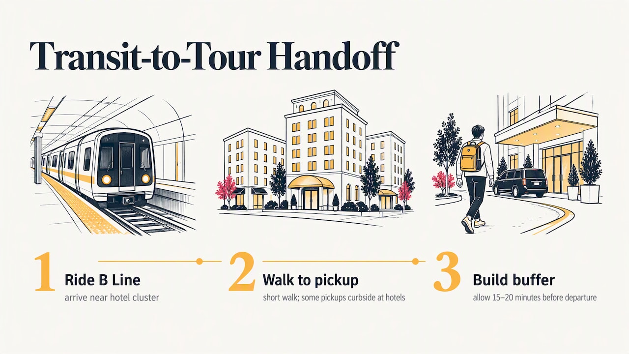
If you’re riding Metro for part of your day and joining a guided tour for the rest, timing the handoff matters. Most tour pick-up points sit near major hotel clusters in Hollywood, which lines up well with B Line stops, so you can ride the subway in and walk a short distance to your pick-up location rather than paying for a longer rideshare. Check your tour confirmation for the exact meeting point, since some pick-ups happen curbside at a hotel rather than at a dedicated depot.
Building a small buffer, 15 to 20 minutes, between your last transit leg and your tour’s scheduled departure gives you room for a delayed train or a slower-than-expected walk. Our walking tour versus bus comparison covers how to decide which mode gets you to a meeting point fastest depending on where you’re coming from. For visitors staying Downtown or in Hollywood proper, the subway-to-pickup handoff is usually the smoothest part of the day, since both ends sit inside the same walkable cluster.
Accessibility on Transit and Tours
Metro rail stations are built with elevators and ramps, and buses kneel and deploy ramps for wheelchair users, a detail covered in Metro’s official schedules and rail map. Strollers are generally welcome on both rail and bus, though priority seating areas are reserved for riders with mobility needs, so be ready to fold a stroller if a bus fills up.
For tours, accessibility varies by vehicle and route, so it’s worth confirming wheelchair access or stroller policies directly with the operator before booking, especially for stops that involve walking on uneven terrain, like the trail views near the Hollywood Sign. Planning ahead here avoids a frustrating surprise on the day of your visit.
Carrying Cameras, Shopping Bags, and Gear on Transit
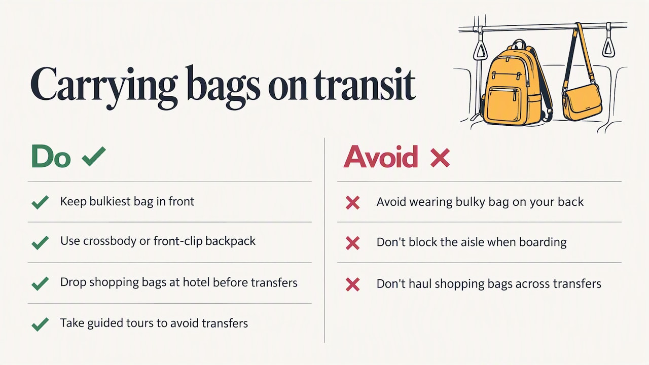
Tourists often end up juggling a camera bag, a day pack, and a shopping bag or two by midafternoon, and transit isn’t always forgiving of that. Keep your bulkiest bag in front of you rather than on your back when boarding a crowded train, both for your own balance and to avoid blocking the aisle.
A crossbody bag or a backpack with a front clip keeps your hands free for tapping a TAP card and holding a rail. If you’ve been shopping along Hollywood Boulevard or Rodeo Drive, consider dropping bags back at your hotel before continuing to your next stop rather than hauling them across a transfer. Guided tours sidestep this entirely since your bags stay with you on the bus rather than through multiple transfers.
How Weather Affects Your Walking and Waiting Times
Los Angeles weather is mild most of the year, but it still shapes how a car-free day plays out. A sunny, 85-degree afternoon makes waiting at an open-air bus stop far less pleasant than riding the subway, so on hot days, lean toward rail legs and save bus connectors for the morning or evening.
The rare rainy day in winter slows everything down, since sidewalks near canyon roads and hillside viewpoints can get slick, and bus schedules can slip during heavier traffic. Check the forecast the morning of any outdoor-heavy day, like a Griffith Observatory visit or a Hollywood Sign photo stop, and build in extra buffer time if rain is likely.
A Realistic Take on Car-Free Life in LA
Visiting and living here demand different definitions of success. A visitor wins by covering a short list of highlights with minimal transfers and reasonable time spent waiting. A resident wins by choosing a neighborhood based on job access and bus or rail frequency, not just rent. Neither requires owning a car, but both require planning around one.
— vincent
Skip the Transfers: Book a Guided Tour Instead
A guided tour solves the car-free puzzle in one booking: no transfers, no fare cards, no checking service alerts before you leave. We pick you up, handle the route, and narrate the highlights in more than 11 languages while you sit back in a small group rather than a packed bus.
If the Hollywood Sign and the Walk of Fame are on your list, our Hollywood Sign Tour covers both without a single transfer. Want Hollywood and the coast in the same day? Our Hollywood to Santa Monica Tour connects the two neighborhoods that otherwise require a rail switch and a longer walk. Check availability on our booking calendar and pick the time slot that fits around your transit day.
FAQ
Is it possible to get around Los Angeles without a car?
Yes, Metro rail lines like the A, B, D, E, C, and K cover most major visitor corridors, and frequent buses fill the gaps, according to Metro’s rail map. Pairing transit with walking, bike share, and the occasional rideshare or guided tour covers nearly every visitor itinerary.
Can you survive in Los Angeles without a car as a resident?
It depends heavily on neighborhood and job location. Reporting from LAist frames reducing car dependence as a more realistic goal than full car-free living for most residents, since job access and neighborhood design shape how workable it is.
What are the no-go zones for transit in LA?
There’s no official “no-go” list, but some attractions, like Malibu or the Getty, are more time-consuming to reach by public transit than by car, according to Business Insider’s reporting on a car-free LA visit. For those spots, a guided tour or a short rideshare often makes more sense than piecing together multiple bus transfers.
Where should I stay in LA if I don’t have a car?
Target Downtown LA, Hollywood, Santa Monica, or the Culver City museum corridor, since each sits on or near a Metro rail line. Discover Los Angeles recommends treating the city as a set of walkable neighborhood clusters and choosing lodging inside one of them rather than trying to cover the whole county each day.
How much does it cost to ride Metro during a visit?
Metro’s fare-capping means you never pay more than the daily cap of about $5 or the weekly cap of about $18 once you hit it, as long as you pay with a TAP card or contactless payment, according to Metro’s fare page. Cash payments on buses require exact fare and don’t count toward the cap.
Sources
- Metro schedules and rail map
- Car Free LA | Discover Los Angeles
- Tips for visiting Los Angeles without a car (Business Insider)
- Los Angeles Metro overview (Visit California)